
Snow Crab Fishing Areas
Disclaimer: The maps on this site have been prepared for convenience of reference only (visual aid) and do not have official sanction. All maps are drawn in North American Datum of 1927 (NAD27).
Snow Crab Fishing Areas – Map
Map showing the boundary lines of the snow crab fishing areas in the Gulf of St. Lawrence. There are nine snow crab fishing areas and each area is assigned a name. The names of the snow crab fishing areas are as follows: Area 12, Area 12E, Area 12F, Area 18, Area 19, Area 25, Area 26, Buffer Area F, and Buffer Area 18. Each fishing area is delimited by specific geographical coordinates.
All areas are listed in a text format at the bottom of this map.

Click on an area to view the Latitude and longitude
Area 12

Snow Crab Fishing Area 12 - Map
Map showing the boundary lines of the snow crab fishing area 12 in the Gulf of St. Lawrence. The area covers most of the Gulf of St. Lawrence, except for an area north of Prince Edward Island, several areas west of Cape Breton, Nova Scotia, and two areas north and east of the Magdalene islands.
| Point | Latitude - North | Longitude - West |
|---|---|---|
| 1. | 45° 58′ 00″ | 61° 32′ 00″ |
| 2. | 45° 59′ 00″ | 61° 36′ 00″ |
| 3. | 46° 18′ 01″ | 62° 20′ 00″ |
| 4. | 47° 03′ 30″ | 64° 00′ 00″ |
| 5. | 47° 15′ 00″ | 64° 00′ 00″ |
| 6. | 46° 37′ 30″ | 61° 30′ 15″ |
| 7. | 47° 30′ 00″ | 60° 43′ 20″ |
| 8. | 47° 26′ 45″ | 61° 00′ 00″ |
| 9. | 47° 50′ 00″ | 61° 08′ 25″ |
| 10. | 47° 58′ 30″ | 61° 07′ 30″ |
| 11. | 48° 31′ 00″ | 63° 08′ 30″ |
| 12. | 49° 00′ 00″ | 63° 08′ 30″ |
| 13. | 49° 40′ 20″ | 64° 54′ 50″ |
| 14. | 49° 21′ 25″ | 65° 35′ 30″ |
| 15. | 49° 17′ 00″ | 64° 44′ 00″ |
| 16. | 48° 53′ 30″ | 63° 48′ 54″ |
| 17. | 48° 45′ 18″ | 64° 09′ 54″ |
Table description:
Table showing the coordinates that represent the boundary lines of the snow crab fishing area 12 in the Gulf of St. Lawrence. Row one is the title. Column one represents the label given to each coordinate. Column two represents the latitude coordinate for each point. Column three represents the longitude coordinate for each point.
Area 12E

Snow Crab Fishing Area 12E - Map
Map showing the boundary lines of the snow crab fishing area 12E in the Gulf of St. Lawrence. The area has a trapezoid shape and it is located to the north of the Magdalene Islands and to the east of the Gaspé peninsula.
| Point | Latitude - North | Longitude - West |
|---|---|---|
| 1. | 47° 58′ 30″ | 61° 07′ 30″ |
| 2. | 48° 02′ 30″ | 61° 07′ 00″ |
| 3. | 49° 00′ 00″ | 63° 08′ 30″ |
| 4. | 48° 31′ 00″ | 63° 08′ 30″ |
Table description:
Table showing the coordinates that represent the boundary lines of the Snow crab Fishing Area 12E in the Gulf of St. Lawrence. Row one is the title. Column one represents the label given to each coordinate. Column two represents the latitude coordinate for each point. Column three represents the longitude coordinate for each point.
Area 12F

Snow Crab Fishing Area 12F - Map
Map showing the boundary lines of the snow crab fishing area 12F in the Gulf of St. Lawrence. The area is located approximately 30 kilometers to the east of the Magdalene Islands.
| Point | Latitude - North | Longitude - West |
|---|---|---|
| 1. | 47° 18′ 30″ | 60° 18′ 00″ |
| 2. | 47° 21′ 30″ | 60° 16′ 00″ |
| 3. | 47° 44′ 30″ | 60° 25′ 15″ |
| 4. | 48° 02′ 30″ | 61° 07′ 00″ |
| 5. | 47° 58′ 30″ | 61° 07′ 30″ |
| 6. | 47° 50′ 00″ | 61° 08′ 25″ |
| 7. | 47° 26′ 45″ | 61° 00′ 00″ |
| 8. | 47° 30′ 00″ | 60° 43′ 20″ |
| 9. | 47° 32′ 12″ | 60° 42′ 15″ |
Table description:
Table showing the coordinates that represent the boundary lines of the Snow crab Fishing Area 12F in the Gulf of St. Lawrence. Row one is the title. Column one represents the label given to each coordinate. Column two represents the latitude coordinate for each point. Column three represents the longitude coordinate for each point.
Area 18

Snow Crab Fishing Area 18 - Map
Map showing the boundary lines of the snow crab fishing area 18 in the Gulf of St. Lawrence. The area is rectangular in shape and it is located in the eastern half of Northumberland Strait between Prince Edward Island and Cape Breton, Nova Scotia. It covers a portion of the western coast of Cape Breton, Nova Scotia, from Port Hood to Saint Rose.
| Point | Latitude - North | Longitude - West |
|---|---|---|
| 1. | 45° 58′ 00″ | 61° 32′ 00″ |
| 2. | 45° 59′ 00″ | 61° 36′ 00″ |
| 3. | 46° 09′ 00″ | 61° 57′ 00″ |
| 4. | 46° 33′ 15″ | 61° 34′ 12″ |
| 5. | 46° 21′ 40″ | 61° 11′ 09″ |
Table description:
Table showing the coordinates that represent the boundary lines of the Snow crab Fishing Area 18 in the Gulf of St. Lawrence. Row one is the title. Column one represents the label given to each coordinate. Column two represents the latitude coordinate for each point. Column three represents the longitude coordinate for each point.
Area 19

Snow Crab Fishing Area 19 - Map
Map showing the boundary lines of the snow crab fishing area 19 in the Gulf of St. Lawrence. The area is rectangular in shape and it is located along the northwestern coast of Cape Breton, from Margaree Harbour to Bay St. Lawrence.
| Point | Latitude - North | Longitude - West |
|---|---|---|
| 1. | 46° 25′ 40″ | 61° 07′ 00″ |
| 2. | 46° 37′ 30″ | 61° 30′ 15″ |
| 3. | 47° 30′ 00″ | 60° 43′ 20″ |
| 4. | 47° 16′ 25″ | 60° 17′ 40″ |
| 5. | 47° 02′ 15″ | 60° 24′ 55″ |
Table description:
Table showing the coordinates that represent the boundary lines of the Snow crab Fishing Area 19 in the Gulf of St. Lawrence. Row one is the title. Column one represents the label given to each coordinate. Column two represents the latitude coordinate for each point. Column three represents the longitude coordinate for each point.
Area 25
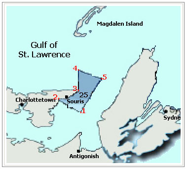
Snow Crab Fishing Area 25 - Map
Map showing the boundary lines of the snow crab fishing area 25 in the Gulf of St. Lawrence. The area covers the northeastern coast of Prince Edward Island, from Howe Bay to East Point.
| Point | Latitude - North | Longitude - West |
|---|---|---|
| 1. | 46° 09′ 00″ | 61° 57′ 00″ |
| 2. | 46° 18′ 01″ | 62° 20′ 00″ |
| 3. | 46° 27′ 00″ | 61° 58′ 00″ |
| 4. | 46° 45′ 00″ | 62° 00′ 00″ |
| 5. | 46° 37′ 30″ | 61° 30′ 15″ |
Table description:
Table showing the coordinates that represent the boundary lines of the Snow crab Fishing Area 25 in the Gulf of St. Lawrence. Row one is the title. Column one represents the label given to each coordinate. Column two represents the latitude coordinate for each point. Column three represents the longitude coordinate for each point.
Area 26

Snow Crab Fishing Area 26 - Map
Map showing the boundary lines of the snow crab fishing area 26 in the Gulf of St. Lawrence. The area includes the entire north coast of Prince Edward Island - the side that faces the Gulf of St. Lawrence.
| Point | Latitude - North | Longitude - West |
|---|---|---|
| 1. | 47° 03′ 30″ | 64° 00′ 00″ |
| 2. | 47° 15′ 00″ | 64° 00′ 00″ |
| 3. | 46° 45′ 00″ | 62° 00′ 00″ |
| 4. | 46° 27′ 00″ | 61° 58′ 00″ |
Table description:
Table showing the coordinates that represent the boundary lines of the Snow crab Fishing Area 26 in the Gulf of St. Lawrence. Row one is the title. Column one represents the label given to each coordinate. Column two represents the latitude coordinate for each point. Column three represents the longitude coordinate for each point.
Buffers

Snow Crab Buffer Area 18 - Map
Map showing the boundary lines of the snow crab buffer area 18 in the Gulf of St. Lawrence. The rectangular area covers the western coast of Cape Breton, Nova Scotia, from Saint Rose to Margaree harbour. The area also extends from the coast to approximately 35 kilometers out at sea.
Snow Crab Buffer Area F - Map
Map showing the boundary lines of the snow crab buffer area F in the Gulf of St. Lawrence. The rectangular area is located at approximately 52 kilometers to the east of the Magdalene islands.
| Point | Latitude - North | Longitude - West |
|---|---|---|
| 1. | 46° 21′ 40″ | 61° 11′ 09″ |
| 2. | 46° 33′ 15″ | 61° 34′ 12″ |
| 3. | 46° 37′ 30″ | 61° 30′ 15″ |
| 4. | 46° 25′ 40″ | 61° 07′ 00″ |
Snow Crab Buffer Area 18 - Table description:
Table showing the coordinates that represent the boundary lines of the snow crab buffer area 18 in the Gulf of St. Lawrence. Row one is the title. Column one represents the label given to each coordinate. Column two represents the latitude coordinate for each point. Column three represents the longitude coordinate for each point.
| Point | Latitude - North | Longitude - West |
|---|---|---|
| 1. | 47° 30′ 00″ | 60° 43′ 20″ |
| 2. | 47° 32′ 12″ | 60° 42′ 15″ |
| 3. | 47° 18′ 30″ | 60° 18′ 00″ |
| 4. | 47° 16′ 25″ | 60° 17′ 40″ |
Snow Crab Buffer Area F - Table description:
Table showing the coordinates that represent the boundary lines of the snow crab buffer area F in the Gulf of St. Lawrence. Row one is the title. Column one represents the label given to each coordinate. Column two represents the latitude coordinate for each point. Column three represents the longitude coordinate for each point.