
Rock Crab Fishing Areas
Disclaimer: The maps on this site have been prepared for convenience of reference only (visual aid) and do not have official sanction. All maps are drawn in North American Datum of 1927 (NAD27).
Rock Crab Fishing Areas – Map
Map showing the boundary lines of the rock crab fishing areas in the Gulf of St. Lawrence. There are six rock crab fishing areas and each area is assigned a name. The names of the rock crab fishing areas are as follows: Area 23, Area 24, Area 25, Area 26A, Area 26B, and Area 27. Each fishing area is delimited by specific geographical coordinates.
All areas are listed in a text format at the bottom of this map.

Click on an area to view the Latitude and longitude
Area 23
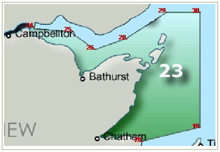
Rock Crab Fishing Area 23 - Map
Map showing the boundary lines of the rock crab fishing area 23 in the Gulf of St. Lawrence. The first point originates near Dalhousie, New Brunswick and five other points divide the Bay of Chaleur in half. The rock crab fishing area 23 includes the southern half of the Bay of Chaleur, all of the coast of the Acadian peninsula, and Miramichi Bay.
| Point | Latitude - North | Longitude - West |
|---|---|---|
| 24. | 48° 03′ 18″ | 66° 19′ 21″ |
| 25. | 48° 01′ 30″ | 65° 50′ 00″ |
| 26. | 47° 51′ 42″ | 65° 29′ 10″ |
| 28. | 47° 57′ 45″ | 65° 03′ 30″ |
| 29. | 48° 12′ 15″ | 64° 30′ 00″ |
| 30. | 48° 12′ 15″ | 64° 02′ 10″ |
| 19. | 47° 08′ 25″ | 64° 02′ 10″ |
| 20. | 47° 00′ 48″ | 64° 49′ 40″ |
Table description:
Table showing the coordinates that represent the boundary lines of the rock crab fishing area 23 in the Gulf of St. Lawrence. Row one is the title. Column one represents the label given to each coordinate. Column two represents the latitude coordinate for each point. Column three represents the longitude coordinate for each point.
Area 24

Rock Crab Fishing Area 24 - Map
Map showing the boundary lines of the rock crab fishing area 24 in the Gulf of St. Lawrence. The area includes the entire north coast of Prince Edward Island - the side that faces the Gulf of St. Lawrence. The first point originates near North Cape, Prince Edward Island. A straight line is drawn to a second point about 10 kilometers north. Another line is drawn between the second point and a third point approximately 250 kilometers to the east, near the northern tip of Cape Breton, Nova Scotia. A last line is drawn between the third point and a fourth and fifth point near East Point, Prince Edward Island.
| Point | Latitude - North | Longitude - West |
|---|---|---|
| 18. | 47° 03′ 27″.7 (NAD-83) |
63° 59′ 48″.8 (NAD-83) |
| 19. | 47° 08′ 25″ | 64° 02′ 10″ |
| 12. | 47° 02′ 18″ | 60° 45′ 00″ |
| 50. | 46° 37′ 30″ | 61° 30′ 15″ |
| 13. | 46° 27′ 52″ | 61° 51′ 06″ |
| 14. | 46° 26′ 55″ | 61° 58′ 25″ |
Table description:
Table showing the coordinates that represent the boundary lines of the rock crab fishing area 24 in the Gulf of St. Lawrence. Row one is the title. Column one represents the label given to each coordinate. Column two represents the latitude coordinate for each point. Column three represents the longitude coordinate for each point.
Area 25

Rock crab Fishing Area 25 - Map
Map showing the boundary lines of the rock crab fishing area 25 in the Gulf of St. Lawrence. The area includes the northwestern part of Northumberland Strait between New Brunswick and Prince Edward Island.
| Point | Latitude - North | Longitude - West |
|---|---|---|
| 20. | 47° 00′ 48″ | 64° 49′ 40″ |
| 19. | 47° 08′ 25″ | 64° 02′ 10″ |
| 18. | 47° 03′ 27″.7 (NAD-83) |
63° 59′ 48″.8 (NAD-83) |
| 17. | 46° 12′ 58″ | 63° 29′ 26″ |
| 16. | 46° 10′ 35″ | 63° 28′ 03″ |
| 15. | 45° 51′ 45″ | 63° 42′ 42″ |
Table description:
Table showing the coordinates that represent the boundary lines of the rock crab fishing area 25 in the Gulf of St. Lawrence. Row one is the title. Column one represents the label given to each coordinate. Column two represents the latitude coordinate for each point. Column three represents the longitude coordinate for each point.
Area 26A
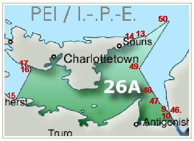
Rock Crab Fishing Area 26A - Map
Map showing the boundary lines of the rock crab fishing area 26A in the Gulf of St. Lawrence. The area includes the southeastern part of Northumberland Strait between Nova Scotia and Prince Edward Island and the western half between Prince Edward Island and Cape Breton, Nova Scotia.
| Point | Latitude - North | Longitude - West |
|---|---|---|
| 15. | 45° 51′ 45″ | 63° 42′ 42″ |
| 16. | 46° 10′ 35″ | 63° 28′ 03″ |
| 17. | 46° 12′ 58″ | 63° 29′ 26″ |
| 14. | 46° 27′ 55″ | 61° 58′ 25″ |
| 13. | 46° 27′ 52″ | 61° 51′ 00″ |
| 50. | 46° 37′ 30″ | 61° 30′ 15″ |
| 49. | 46° 09′ 00″ | 61° 57′ 00″ |
| 48. | 45° 50′ 00″ | 61° 40′ 00″ |
| 47. | 45° 43′ 42″ | 61° 30′ 42″ |
| 10. | 45° 38′ 10″ | 61° 25′ 45″ |
| 9. | 45° 38′ 30″ | 61° 24′ 15″ |
| 46. | 45° 41′ 30″ | 61° 29′ 20″ |
Table description:
Table showing the coordinates that represent the boundary lines of the rock crab fishing area 26A in the Gulf of St. Lawrence. Row one is the title. Column one represents the label given to each coordinate. Column two represents the latitude coordinate for each point. Column three represents the longitude coordinate for each point.
Area 26B

Rock Crab Fishing Area 26B - Map
Map showing the boundary lines of the rock crab fishing area 26B in the Gulf of St. Lawrence. The area includes the eastern half of Northumberland Strait between Prince Edward Island and Cape Breton, Nova Scotia and the entire western coast of Cape Breton, Nova Scotia.
| Point | Latitude - North | Longitude - West |
|---|---|---|
| 46. | 45° 41′ 30″ | 61° 29′ 20″ |
| 9. | 45° 38′ 30″ | 61° 24′ 15″ |
| 10. | 45° 38′ 10″ | 61° 25′ 45″ |
| 47. | 45° 43′ 42″ | 61° 30′ 42″ |
| 48. | 45° 50′ 00″ | 61° 40′ 00″ |
| 49. | 46° 09′ 00″ | 61° 57′ 00″ |
| 50. | 46° 37′ 30″ | 61° 30′ 15″ |
| 12. | 47° 02′ 18″ | 60° 45′ 00″ |
| 11. | 46° 58′ 42″ | 60° 40′ 00″ |
Table description:
Table showing the coordinates that represent the boundary lines of the rock crab fishing area 26B in the Gulf of St. Lawrence. Row one is the title. Column one represents the label given to each coordinate. Column two represents the latitude coordinate for each point. Column three represents the longitude coordinate for each point.
Area 27

Rock Crab Fishing Area 27 - Map
Map showing the boundary lines of the rock crab fishing area 27 in the Gulf of St. Lawrence. The area is rectangular in shape. It covers the northeastern coast of Cape Breton, Nova Scotia and approximately three quarters of Cabot Strait between Cape Breton, Nova Scotia and Newfoundland. The area also covers a portion of the Atlantic Ocean to the southeast of Cape Breton, Nova Scotia.
| Point | Latitude - North | Longitude - West |
|---|---|---|
| 11. | 46° 58′ 42″ | 60° 40′ 00″ |
| 12. | 47° 02′ 18″ | 60° 45′ 00″ |
| 3. | 47° 50′ 00″ | 60° 00′ 00″ |
| 4. | 46° 00′ 00″ | 57° 50′ 00″ |
| 5. | 44° 56′ 00″ | 59° 42′ 00″ |
| 6. | 45° 47′ 00″ | 60° 11′ 00″ |
Table description:
Table showing the coordinates that represent the boundary lines of the rock crab fishing area 27 in the Gulf of St. Lawrence. Row one is the title. Column one represents the label given to each coordinate. Column two represents the latitude coordinate for each point. Column three represents the longitude coordinate for each point.