
Moncton, New Brunswick (NB) – June 18, 2026 – This Conservation Harvesting Plan (CHP) presents the management measures for herring licence holders using mobile gear (purse seine) and vessels greater than 19.81 metres (large seiners) for the Edge fishery.
An interim TAC of 1,000 tonne (t) is authorized for fishing activities from May 15 to June 30, 2026, only in the northern portion of Herring Fishing Area (HFA) 16D called the Edge (see Chart 1).
New 2026 management measure for the Edge fishery
The percentage of the spring spawners will be monitored for each fishing trip using a scientific protocol to determine catch composition (see Annex 1).
The fall fishery for the large seiners will be closed for the season when either of the following occurs:
- exceeding 10% of spring spawner by-catch per fishing trip for two consecutive trips, or
- a total amount of 25 t of spring spawner by-catch has been caught.
Other management measures
- The minimum sampling coverage of the At-Sea Observer (ASO) Program is 100%.
- The purse seine fishery is subject to the small fish protocol.
- The logbook is mandatory and must be completed on each fishing day.
- Any allocation overrun will be reconciled against the remaining fall allocation of the fleet.
- All vessels must be equipped with an operational Vessel Monitoring System (VMS) during their fishing activities.
For further information on fishing requirements and restrictions, licence holders must refer to their licence conditions.
Chart 1
Northern portion of HFA 16D named the Edge (area in blue).
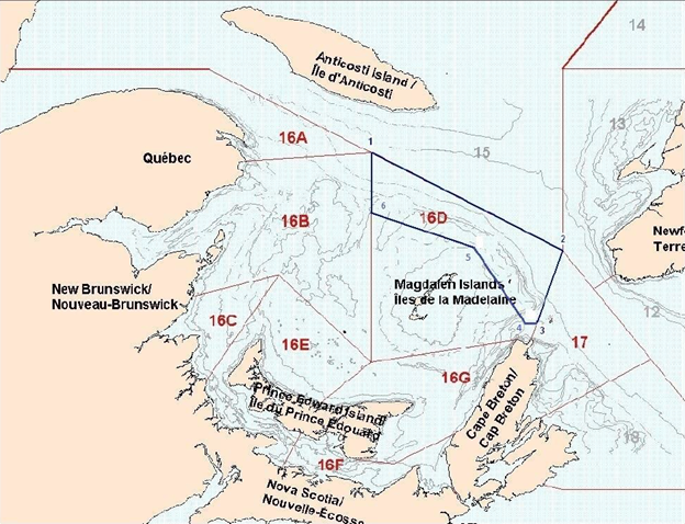
Definition of the northern portion of HFA 16D named the Edge
During the period May 1 to June 30, purse seine fishing is restricted to the waters enclosed by rhumb lines (similar to straight lines drawn on a nautical chart) joining the following points in the order they are listed:
| Points | Latitude north | Longitude west |
|---|---|---|
| 1 | 48°42’00” N | 62°32’00” W |
| 2 | 47°50’00” N | 60°00’00” W |
| 3 | 47°11’06” N | 60°20’07” W |
| 4 | 47°11’06” N | 60°35’52” W |
| 5 | 47°51’33” N | 61°10’07” W |
| 6 | 48°09’33” N | 62°32’02” W |
Note: When the geographic boundary of an area is expressed in latitude and longitude, these point references are based on the geodesic system North American Datum 1927 (NAD27). The positions are expressed in degrees, minutes and seconds.
Annex 1
Scientific Protocol to Identify the Spring Spawner Component during the Herring Fall Fishery on the Edge
The following biological sampling of herring is required for each landing by the Gulf purse seine fleet during the fall fishery:
- A total of at least 200 herrings, randomly selected, must be sampled for each trip.
- If no DFOs port samplers are available to collect the fish at landing, all herring samples must be placed in a few clearly identified plastic bags and then inside a sample box. Required information must be written directly on the box. Each box should be frozen as quickly as possible and stored.
- All pertinent information, such as the vessel name, date and time of the catch, fishing area, and especially the position coordinates (latitude /longitude) where the herring was caught must be provided.
- If a port sampler is available, DFO is responsible for transporting the samples to the Gulf Fishery Centre in Moncton (GFC). Otherwise, the fishers will be responsible for shipping the frozen samples to the GFC.
- A logbook form must be filled out for each trip.
FOR MORE INFORMATION PLEASE CONTACT:
Laurie Maynard
Email: Laurie.Maynard@dfo-mpo.gc.ca
Tel: 506-269-4274