
Groundfish Fishing Areas
Disclaimer: The maps on this site have been prepared for convenience of reference only (visual aid) and do not have official sanction. All maps are drawn in North American Datum of 1927 (NAD27).
Map of Groundfish Fishing Areas – Map
Map showing the boundary lines of the groundfish fishing areas in the Gulf of St. Lawrence. There are twelve groundfish fishing areas and each area is assigned a name. The names of the groundfish fishing areas are as follows: Area 4T1, Area 4T2A, Area 4T2B, Area 4T3A, Area 4T3B, Area 4T4, Area 4T5, Area 4T6, Area 4T7, Area 4T8, Area 4T9A, and Area 4T9B. Each fishing area is delimited by specific geographical coordinates.
All areas are listed in a text format at the bottom of this map.
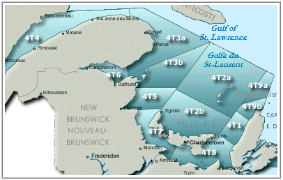
Click on an area to view the Latitude and longitude
- Area 4T1
- Area 4T2A
- Area 4T2B
- Area 4T3A
- Area 4T3B
- Area 4T4
- Area 4T5
- Area 4T6
- Area 4T7
- Area 4T8
- Area 4T9A
- Area 4T9B
Area 4T1
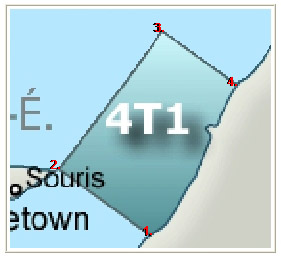
Groundfish Fishing Area 4T1 - Map
Map showing the boundary lines of the groundfish fishing area 4T1 in the Gulf of St. Lawrence. Area 4T1 is located between East Point, Prince Edward Island and the western coast of Cape Breton, Nova Scotia.
| Label | Latitude - North | Longitude - West |
|---|---|---|
| 1. | 46° 11′ 00″ | 61° 25′ 30″ |
| 2. | 46° 26′ 54″ | 61° 58′ 24″ |
| 3. | 47° 00′ 00″ | 61° 21′ 24″ |
| 4. | 46° 46′ 36″ | 60° 53′ 30″ |
Table description:
Table showing the coordinates that represent the boundary lines of the Groundfish Fishing Area 4T1 in the Gulf of St. Lawrence. Row one is the title. Column one represents the label given to each coordinate. Column two represents the latitude coordinate for each point. Column three represents the longitude coordinate for each point.
Area 4T2A
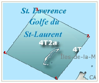
Groundfish Fishing Area 4T2A - Map
Map showing the boundary lines of the groundfish fishing area 4T2A in the Gulf of St. Lawrence. Area 4T2A encompasses all of the Magdalene Islands.
| Label | Latitude - North | Longitude - West |
|---|---|---|
| 1. | 46° 50′ 00″ | 61° 32′ 00″ |
| 2. | 47° 30′ 00″ | 63° 30′ 00″ |
| 3. | 48° 36′ 45″ | 62° 16′ 00″ |
| 4. | 47° 56′ 00″ | 60° 17′ 00″ |
Table description:
Table showing the coordinates that represent the boundary lines of the Groundfish Fishing Area 4T2A in the Gulf of St. Lawrence. Row one is the title. Column one represents the label given to each coordinate. Column two represents the latitude coordinate for each point. Column three represents the longitude coordinate for each point.
Area 4T2B

Groundfish Fishing Area 4T2B - Map
Map showing the boundary lines of the groundfish fishing area 4T2B in the Gulf of St. Lawrence. Area 4T2B includes the entire north coast of Prince Edward Island.
| Label | Latitude - North | Longitude - West |
|---|---|---|
| 1. | 47° 03′ 15″ | 64° 00′ 00″ |
| 2. | 47° 30′ 00″ | 63° 30′ 00″ |
| 3. | 46° 50′ 00″ | 61° 32′ 00″ |
| 4. | 46° 26′ 54″ | 61° 58′ 24″ |
Table description:
Table showing the coordinates that represent the boundary lines of the Groundfish Fishing Area 4T2B in the Gulf of St. Lawrence. Row one is the title. Column one represents the label given to each coordinate. Column two represents the latitude coordinate for each point. Column three represents the longitude coordinate for each point.
Area 4T3A
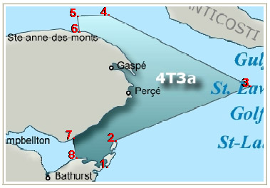
Groundfish Fishing Area 4T3A - Map
Map showing the boundary lines of the groundfish fishing area 4T3A in the Gulf of St. Lawrence. Area 4T3A circles the eastern tip of the Gaspé peninsula and includes the eastern portion of Chaleur Bay.
| Label | Latitude - North | Longitude - West |
|---|---|---|
| 6. | 49° 13′ 36″ | 65° 08′ 00″ |
| 5. | 49° 24′ 00″ | 65° 10′ 00″ |
| 4. | 49° 25′ 00″ | 64° 40′ 00″ |
| 3. | 48° 36′ 45″ | 62° 16′ 00″ |
| 2. | 48° 01′ 00″ | 64° 31′ 00″ |
| 1. | 47° 43′ 00″ | 64° 40′ 00″ |
| 8. | 47° 49′ 00″ | 65° 11′ 00″ |
| 7. | 48° 01′ 00″ | 65° 14′ 40″ |
Table description:
Table showing the coordinates that represent the boundary lines of the Groundfish Fishing Area 4T3A in the Gulf of St. Lawrence. Row one is the title. Column one represents the label given to each coordinate. Column two represents the latitude coordinate for each point. Column three represents the longitude coordinate for each point.
Area 4T3B
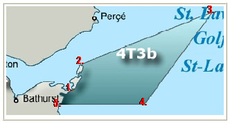
Groundfish Fishing Area 4T3B - Map
Map showing the boundary lines of the groundfish fishing area 4T3B in the Gulf of St. Lawrence. Area 4T3B is to the east and northeast of the Acadian peninsula.
| Label | Latitude - North | Longitude - West |
|---|---|---|
| 1. | 47° 43′ 00″ | 64° 40′ 00″ |
| 2. | 48° 01′ 00″ | 64° 31′ 00″ |
| 3. | 48° 36′ 45″ | 62° 16′ 00″ |
| 4. | 47° 33′ 00″ | 63° 26′ 42″ |
| 5. | 47° 33′ 00″ | 64° 54′ 00″ |
Table description:
Table showing the coordinates that represent the boundary lines of the Groundfish Fishing Area 4T3B in the Gulf of St. Lawrence. Row one is the title. Column one represents the label given to each coordinate. Column two represents the latitude coordinate for each point. Column three represents the longitude coordinate for each point.
Area 4T4

Groundfish Fishing Area 4T4 - Map
Map showing the boundary lines of the groundfish fishing area 4T4 in the Gulf of St. Lawrence. Area 4T4 includes most of the St. Lawrence River.
| Label | Latitude - North | Longitude - West |
|---|---|---|
| 1. | 49° 20′ 00″ | 67° 23′ 00″ |
| 2. | 49° 24′ 00″ | 65° 10′ 00″ |
| 3. | 49° 13′ 36″ | 65° 08′ 00″ |
Table description:
Table showing the coordinates that represent the boundary lines of the Groundfish Fishing Area 4T4 in the Gulf of St. Lawrence. Row one is the title. Column one represents the label given to each coordinate. Column two represents the latitude coordinate for each point. Column three represents the longitude coordinate for each point.
Area 4T5
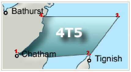
Groundfish Fishing Area 4T5 - Map
Map showing the boundary lines of the groundfish fishing area 4T5 in the Gulf of St. Lawrence. Area 4T5 is a trapezoid-shaped zone north of Northumberland Strait and which is covered from Tracadie-Sheila, New Brunswick to Miramichi, New Brunswick to Tignish, Prince Edward Island.
| Label | Latitude - North | Longitude - West |
|---|---|---|
| 4. | 47° 33′ 00″ | 64° 54′ 00″ |
| 3. | 47° 33′ 00″ | 63° 26′ 42″ |
| 2. | 47° 03′ 15″ | 64° 00′ 00″ |
| 1. | 47° 00′ 48″ | 64° 49′ 40″ |
Table description:
Table showing the coordinates that represent the boundary lines of the Groundfish Fishing Area 4T5 in the Gulf of St. Lawrence. Row one is the title. Column one represents the label given to each coordinate. Column two represents the latitude coordinate for each point. Column three represents the longitude coordinate for each point.
Area 4T6
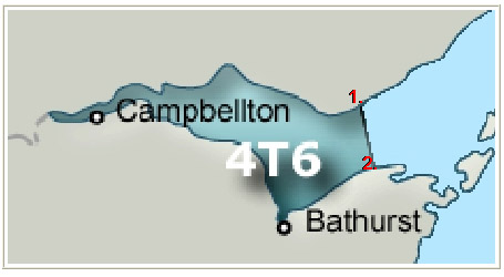
Groundfish Fishing Area 4T6 - Map
Map showing the boundary lines of the groundfish fishing area 4T6 in the Gulf of St. Lawrence. Area 4T6 includes the Bay of Chaleur west of the line that is drawn between Grande-Anse, New Brunswick and Paspébiac, Québec.
| Label | Latitude - North | Longitude - West |
|---|---|---|
| 1. | 48° 01′ 00″ | 65° 14′ 40″ |
| 2. | 47° 49′ 00″ | 65° 11′ 00″ |
Table description:
Table showing the coordinates that represent the boundary lines of the Groundfish Fishing Area 4T6 in the Gulf of St. Lawrence. Row one is the title. Column one represents the label given to each coordinate. Column two represents the latitude coordinate for each point. Column three represents the longitude coordinate for each point.
Area 4T7
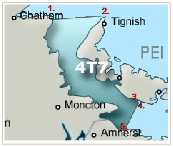
Groundfish Fishing Area 4T7 - Map
Map showing the boundary lines of the groundfish fishing area 4T7 in the Gulf of St. Lawrence. Area 4T7 includes the northwestern part of the Northumberland Strait between New Brunswick and Prince Edward Island.
| Label | Latitude - North | Longitude - West |
|---|---|---|
| 1. | 47° 00′ 48″ | 64° 49′ 40″ |
| 2. | 47° 03′ 15″ | 64° 00′ 00″ |
| 3. | 46° 12′ 53″ | 63° 29′ 26″ |
| 4. | 46° 10′ 35″ | 63° 28′ 03″ |
| 5. | 45° 51′ 45″ | 63° 42′ 42″ |
Table description:
Table showing the coordinates that represent the boundary lines of the Groundfish Fishing Area 4T7 in the Gulf of St. Lawrence. Row one is the title. Column one represents the label given to each coordinate. Column two represents the latitude coordinate for each point. Column three represents the longitude coordinate for each point.
Area 4T8
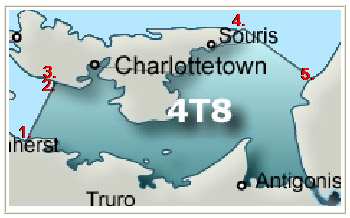
Groundfish Fishing Area 4T8 - Map
Map showing the boundary lines of the groundfish fishing area 4T8 in the Gulf of St. Lawrence. Area 4T8 includes the southeastern part of the Northumberland Strait between Nova Scotia and Prince Edward Island.
| Label | Latitude - North | Longitude - West |
|---|---|---|
| 1. | 45° 51′ 45″ | 63° 42′ 42″ |
| 2. | 46° 10′ 35″ | 63° 28′ 03″ |
| 3. | 46° 12′ 53″ | 63° 29′ 26″ |
| 4. | 46° 26′ 54″ | 61° 58′ 24″ |
| 5. | 46° 11′ 00″ | 61° 25′ 30″ |
Table description:
Table showing the coordinates that represent the boundary lines of the Groundfish Fishing Area 4T8 in the Gulf of St. Lawrence. Row one is the title. Column one represents the label given to each coordinate. Column two represents the latitude coordinate for each point. Column three represents the longitude coordinate for each point.
Area 4T9A
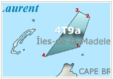
Groundfish Fishing Area 4T9A - Map
Map showing the boundary lines of the groundfish fishing area 4T9A in the Gulf of St. Lawrence. Area 4T9A is to the east of the Magdalene Islands and to the north of Cape Breton, Nova Scotia.
| Label | Latitude - North | Longitude - West |
|---|---|---|
| 4. | 47° 09′ 00″ | 61° 10′ 00″ |
| 3. | 47° 56′ 00″ | 60° 17′ 00″ |
| 2. | 47° 50′ 00″ | 60° 00′ 00″ |
| 1. | 47° 19′ 00″ | 60° 16′ 00″ |
Table description:
Table showing the coordinates that represent the boundary lines of the Groundfish Fishing Area 4T9A in the Gulf of St. Lawrence. Row one is the title. Column one represents the label given to each coordinate. Column two represents the latitude coordinate for each point. Column three represents the longitude coordinate for each point.
Area 4T9B

Groundfish Fishing Area 4T9B - Map
Map showing the boundary lines of the groundfish fishing area 4T9B in the Gulf of St. Lawrence. Area 4T9B is to the southeast of the Magdalene Islands and along the coast of the northern tip of Cape Breton, Nova Scotia.
| Label | Latitude - North | Longitude - West |
|---|---|---|
| 1. | 46° 46′ 36″ | 60° 53′ 30″ |
| 2. | 47° 00′ 00″ | 61° 21′ 24″ |
| 3. | 47° 09′ 00″ | 61° 10′ 00″ |
| 4. | 47° 19′ 00″ | 60° 16′ 00″ |
| 5. | 47° 02′ 09″ | 60° 24′ 33″ |
Table description:
Table showing the coordinates that represent the boundary lines of the Groundfish Fishing Area 4T9B in the Gulf of St. Lawrence. Row one is the title. Column one represents the label given to each coordinate. Column two represents the latitude coordinate for each point. Column three represents the longitude coordinate for each point.