
Maritimes Statistical Districts Map
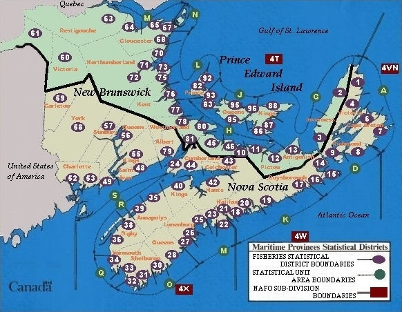
Nova Scotia
- 1 Inverness County line to Path End
- 2 Victoria County line to Broad Cove (exclusive)
- 3 Broad Cove (inclusive) to Richmond County line
- 4 South of Path End (inclusive) line to Cape Breton County
- 6 Victoria County Line to Bridgeport - East Bay (exclusive)
- 7 Bridgeport — East Bay (inclusive) to Richmond County line
- 8 Cape Breton County line to St. Peter's Canal
- 9 St. Peter's Canal to Inverness County line, including Isle Madame.
- 10 Cumberland County line to Pictou County line (Gulf Side)
- 11 Colchester County line to inclusive the western shore of Pictou Harbour and including Pictou Island.
- 12 Inclusive of the eastern shore of Pictou Harbour to the Antigonish County line.
- 13 Antigonish County (all)
- 14 Antigonish County line to exclusive Halfway Cove.
- 15 From inclusive Halfway Cove to inclusive Little Harbour.
- 16 From exclusive Little Harbour to exclusive County Harbour.
- 17 From inclusive County Harbour to Halifax County line.
- 18 Cole Harbour to inclusive the eastern shore of Halifax Harbour to the mouth of the Sackville River.
- 19 Guysborough County line to inclusive Newcombe's Brook, East Ship Harbour.
- 20 Exclusive Newcombe's Brook, East Ship Harbour to Cole Harbour (excl)
- 21 Halifax City, the western shore of Halifax Harbour and Bedford Basin; also inclusive the Sackville and Rawdon Rivers and the Scotia Fat Salvage plant at Fennerty Lake, Sackville N.S.
- 22 Arm Bridge on the western shore of the Northwest Arm to inclusive Black Point, Shad Bay.
- 23 From exclusive Black Point, Shad Bay to Lunenburg County line.
- 24 Cape Chignecto (inclusive) to New Brunswick border
- 25 Halifax County line to inclusive Oakland, Eastern side of Mahone Bay.
- 26 Mahone Bay (inclusive) to La Have River
- 27 La Have River to Queens County line.
- 28 Queens County (all)
- 30 Queens County line to Jordan River
- 31 Jordan River to Barrington River
- 32 Barrington River to Yarmouth county line.
- 33 Shelburne County line to Comeau Hill (inclusive)
- 34 Comeau Hill (exclusive) to Digby County line.
- 35 Hampton to Kings County Line
- 36 Yarmouth County line to Sissiboo River.
- 37 Digby Neck - Brier Island to Rossway (inclusive)
- 38 Sissiboo River to Annapolis County line; Digby neck to Rossway (excl)
- 39 Digby County line to, but not including, Hampton
- 40 Annapolis County line to Cape Split exclusive.
- 41 Cape Split ( inclusive) to Hants County line
- 42 Hants County (all); plus the tidal portion of the Stewiacke River in Colchester County
- 43 Cumberland County line to Hants County line, less the tidal portion of the Stewiacke River
- 44 Colchester County line to Cape Chignecto exclusive.
- 45 New Brunswick border (Northumberland Strait) to Pugwash Point (inclusive) .
- 46 Pugwash Point (exclusive) to Colchester County line.
New Brunswick
- 55 Kings County (All)
- 56 Queens County (All)
- 57 Sunbury County (All)
- 58 York County (All)
- 59 Carleton County (All)
- 60 Victoria County (All)
- 61 Madawaska County (All)
- 48 St. John County, east of the St. John River
- 49 St. John County, west of the St. John River
- 50 Grand Manan Island
- 51 West Isles and Campobello
- 52 International Boundary to Back Bay
- 53 Back Bay to St. John County line at Point Lepreau and including Wolves Islands
- 63 Restigouche County (all)
- 64 Restigouche County line to Bass River (inclusive)
- 65 From Bass River (exclusive) to Pokesudie Island (inclusive)
- 66 Shippegan and Miscou Islands ( inclusive]
- 67 Pokesudie Island (exclusive) to Pokemouche Gully (inclusive)
- 68 Pokemouche Gully (exclusive) to Northumberland County line.
- 70 Gloucester County line to Grand Down Island (inclusive) near Barryville
- 71 Grand Down Island (exclusive) to Morrissey Bridge on the north side of the Miramichi River and from Morrissey Bridge to Point au Carr (inclusive) on the south side of the Miramichi River.
- 72 Morrissey Bridge to Red Bank (inclusive) on the north west Miramichi and from Morrissey Bridge to Quarryville (inclusive) on the south west Miramichi River.
- 73 Point au Carr (exclusive) to Kent County line
- 75 Northumberland County line to the South side of the St. Louis River (inclusive)
- 76 South side of the St. Louis River (exclusive) to Chockpish River (inclusive)
- 77 South side of Chockpish River (exclusive) to Westmorland County line.
- 78 Kent County line to Lower Cape Bald (inclusive)
- 79 Albert County (entire)
- 80 Lower Cape Bald (exclusive) to Nova Scotia Boundary on Northumberland Strait side.
- 81 Westmorland County, Bay of Fundy side, including the Petitcodiac River.
Prince Edward Island
- 82 Baptist Point (incl) to North Point (excl)
- 83 Remainder of Prince County, Northumberland Strait side.
- 85 Prince County line to the Western Outskirts of Charlottetown, Northumberland Strait Side.
- 86 Remainder of Queens County, Northumberland Strait side.
- 87 All of Kings County south of a line from the coast at the south side of Boughton Bay to a line between Queens and Kings Counties.
- 88 Remainder of Kings County.
- 92 North Point (incl) to Cavendish Inlet.
- 93 Remainder of Prince County, Gulf side.
- 95 Queens County, from Prince County line to Tracadie Bay, Gulf side.
- 96 Remainder of Queens County, Gulf side.