
Details on salmon pools closed to angling in the Miramichi system in times of warm water
In accordance with the Warm Water Protocol of the Miramichi River Watershed, the Atlantic salmon pools listed below are closed to recreational fishing when water temperatures become too warm.
In total, the protocol applies to 32 pools along the Miramichi River. During the summer, 29 of them close when water temperatures are too high. When this happens, Fisheries and Oceans Canada (DFO) announces their closure by publishing Notices to recreational anglers online.
Salmon pools at Sutherland Brook, Wilson Brook and Quarryville Brook close on July 1st each year.
Descriptions and geographic coordinates for each salmon pool along the Miramichi River can be found below. To find out if a particular pool is closed, check to see if a closure notice is in effect on the Atlantic salmon web page.
Northwest Miramichi River
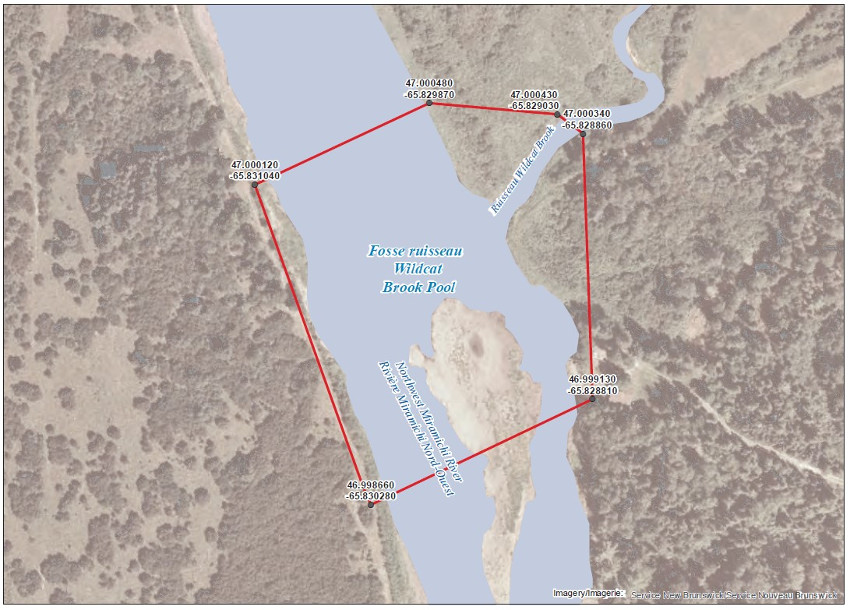
The waters of the Northwest Miramichi River, area located at the mouth of Wildcat Brook including a portion of the said brook. This specific area consist of a portion of the Northwest Miramichi River inside a line drawn from (1) 47.000480, -65.8298870 to (2) 47.000430, -65.829030; then to (3) 46.999130, -65.828810; to (4) 46.998660, -65.830280; to (5) 47.000120, -65.831040 and then to (6) 47.000480, -65.829870;
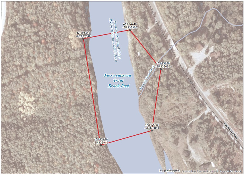
The waters of the Northwest Miramichi River, area located at the mouth of Trout Brook and including a portion of the said brook. This specific area consist of a portion of the Northwest Miramichi River inside a line drawn from (1) 47.094440, -65.836300; to (2) 47.093860, -65.835850; then to (3) 47.092760, -65.835850 to (4) 47.092760, -65.836940; and then to (5) 47.094310, -65.837300;
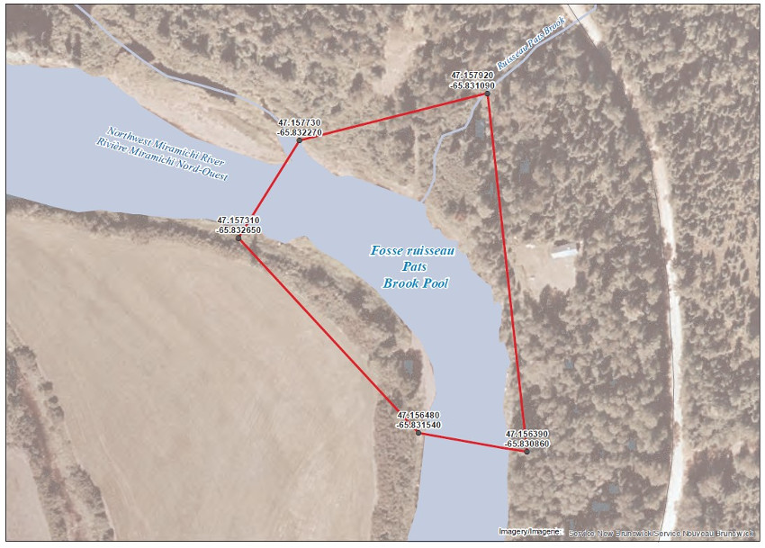
The waters of the Northwest Miramichi River in Wayerton, located at the mouth of Pat’s Brook and including a portion of the said brook. This specific area consist of a portion of the Northwest Miramichi River inside a line drawn from (1) 47.157920, -65.831090 to (2) 47.156390, -65.830860; then to (3) 47.156480, -65.831540 to (4) 47.157310, -65.832650; and then to (5) 47.157730, -65.832270;
Little Southwest Miramichi River
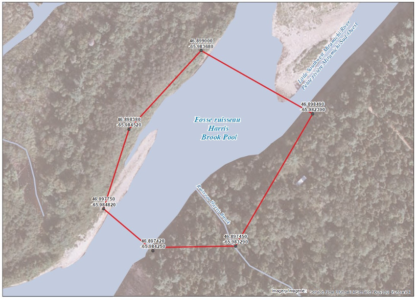
The waters of the Little Southwest Miramichi River, area located at the mouth of Harris Brook and including a portion of the said brook. This specific area consist of a portion of the Little Southwest Miramichi River inside a line drawn from (1) 46.899000, -65.983680; to (2) 46.898490, -65.982390; then to (3) 46.897450, -65.983290 to (4) 46.897420, -65.984250; then to (5) 46.897750, -65.984820 and to (6) 46.898380, -65.984520;
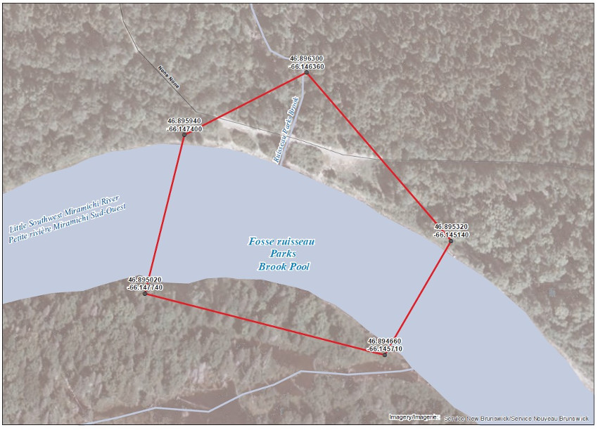
The waters of the Little Southwest Miramichi River, area located at the mouth of Parks Brook and including a portion of the said brook. This specific area consist of a portion of the Little Southwest Miramichi River inside a line drawn from (1) 46.896300, -66.146360; to (2) 46.895320, -66.145140; then to (3) 46.894660, -66.145710 to (4) 46.895020, -66.147740; and then to (5) 46.895940, -66.147400;
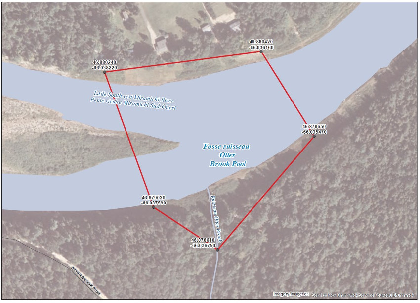
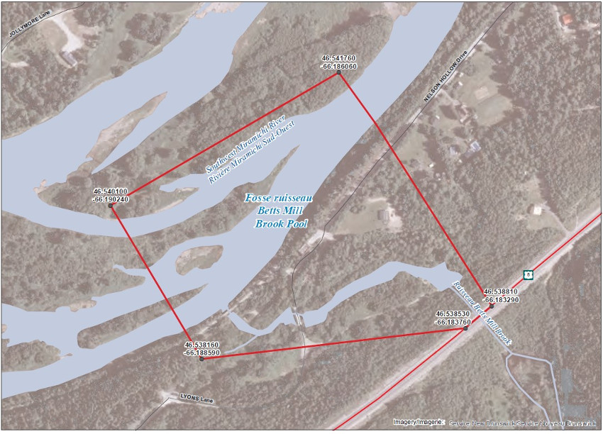
The waters of the Little Southwest Miramichi River, area located at the mouth of Otter Brook and including a portion of the said brook. This specific area consists of a portion of the Little Southwest Miramichi River inside a line drawn from (1) 46.541760, -66.186060 to (2) 46.538810, -66.183290; then to (3) 46.538530, -66.183760 to (4) 46.538160, -66.188560; and then to (5) 46.540100, -66.190240;
Southwest Miramichi River
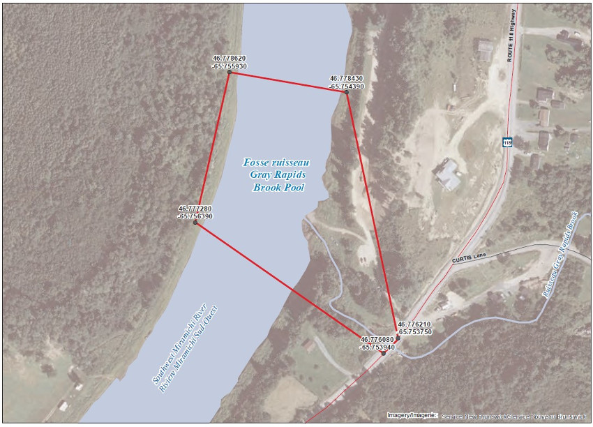
The waters of the Southwest Miramichi River, area located at the mouth Gray Rapids Brook and including a portion of the said brook, locally known as Pete brook. This specific area consist of a portion of the Southwest Miramichi River inside a line drawn from (1) 46.778620, -65.755930 to (2) 46.778430, -65.754390; then to (3) 46.776210, -65.753750 to (4) 46.776080, -65.753940; and then to (5) 46.777280, -65.756390;
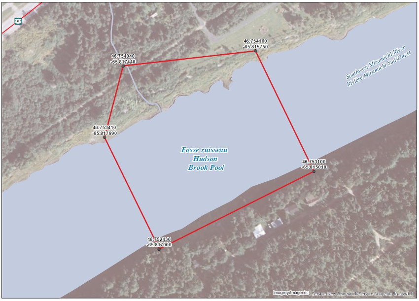
The waters of the Southwest Miramichi River, area located at the mouth of Hudson Brook and including a portion of the said brook. This specific area consist of a portion of the Southwest Miramichi River inside a line drawn from (1) 46.754160, -65.815750 to (2) 46.753100, -65.815010; then to (3) 46.752430, -65.817000 to (4) 46.753410, -65.817690; and then to (5) 46.754040, -65.817440;
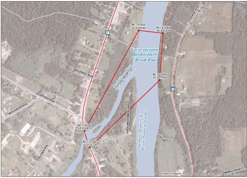
The waters of the Southwest Miramichi River, located at the mouth of Bartholomew River and including a portion of the said river. This specific area consists of a portion of the Southwest Miramichi River inside a line drawn from (1)46.753280, -65.825290 to (2) 46.741090, -65.825560; then to (3) 46.737990, -65.830320 to (4) 46.738760, -65.830670; and then to (5) 46.743420, -65.826940;
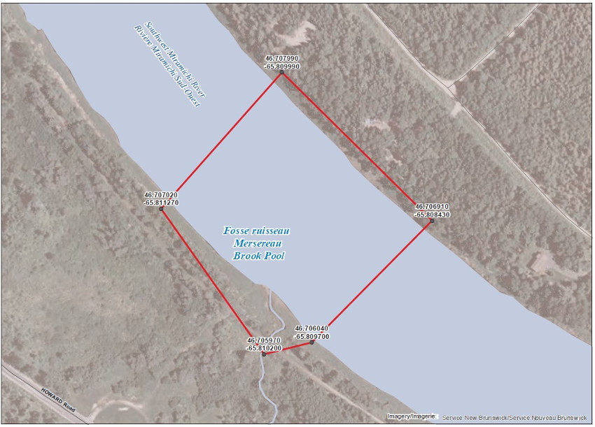
The waters of the Southwest Miramichi River, area located at the mouth of Mersereau Brook and including a portion of the said brook. This specific area consist of a portion of the Southwest Miramichi River inside a line drawn from (1) 46.707990, -65.809990 to (2) 46.706910, -65.808430; then to (3) 46.706040, -65.809700 to (4) 46.705970, -65.810200; and then to (5) 46.707020, -65.811270 ;
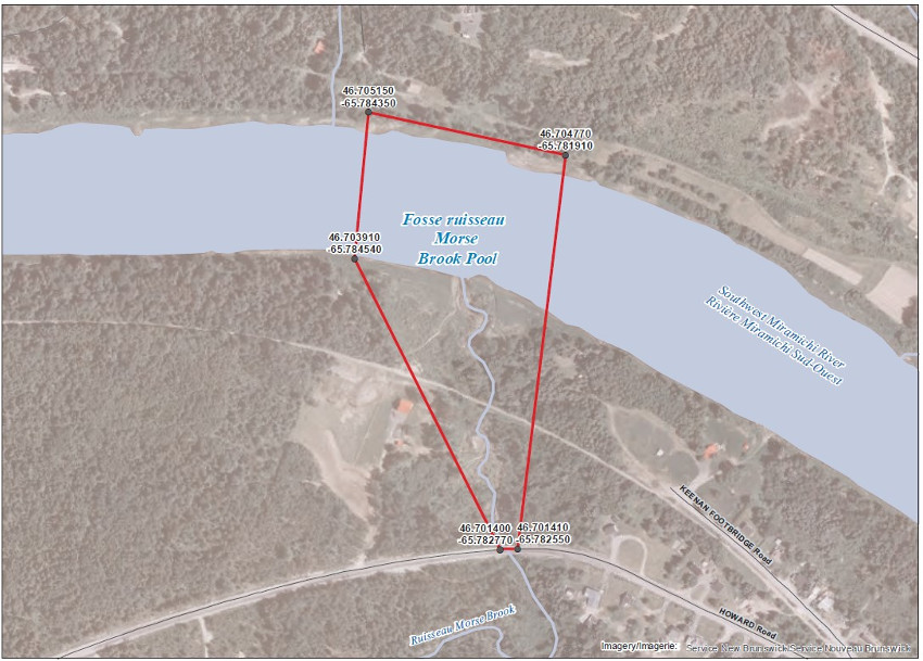
The waters of the Southwest Miramichi River, area located at the mouth of Morse Brook and including a portion of the said brook. This specific area consist of a portion of the Southwest Miramichi River inside a line drawn from (1) 46.705150, -65.784350 to (2) 46.704770, -65.781910; then to (3) 46.701410, -65.782550 (4) 46.701400, -65.782770; and then to (5) 46.703910, -65.784540;
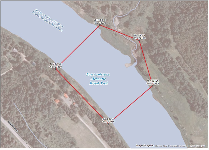
The waters of the Southwest Miramichi River, area located at the mouth of McKenzie Brook and including a portion of the said brook. This specific area consists of a portion of the Southwest Miramichi River inside a line drawn from (1) 46.700890, -65.773220 to (2) 46.700590, -65.772120; then to (3) 46.699700, -65.771740 to (4) 46.698960, -65.773020 and then to (5) 46.700050, -65.774490;
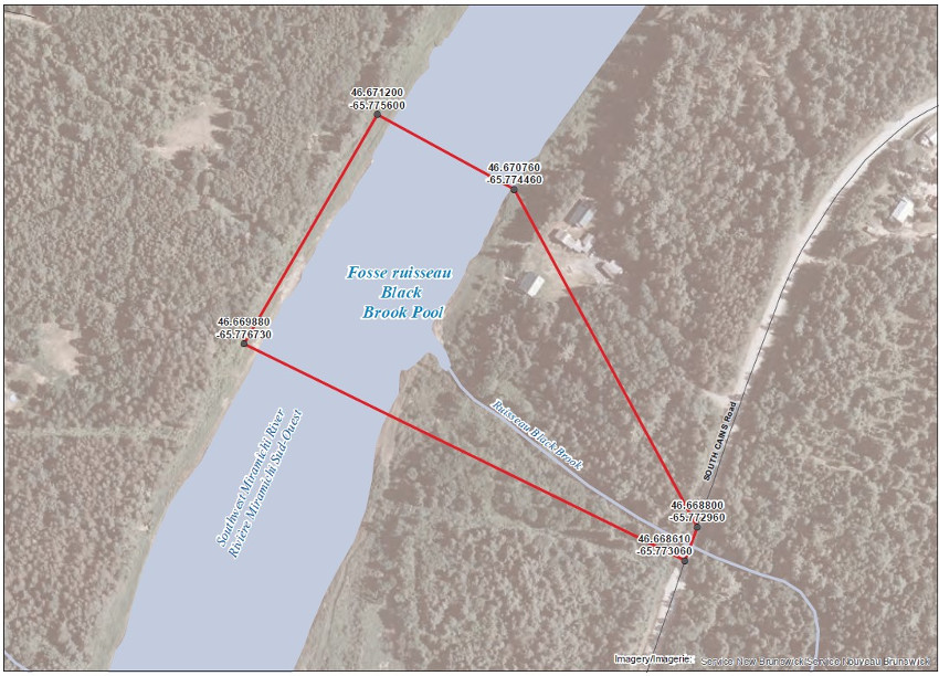
The waters of the Southwest Miramichi River, area located at the mouth of Black Brook and including a portion of the said brook. This specific area consist of a portion of the Southwest Miramichi River inside a line drawn from (1) 46.671200, -65.775600 to (2) 46.670760, -65.774460; then to (3) 46.668800, -65.772960 to (4) 46.668610, -65.773060; and then to (5) 46.669880, -65.776730;
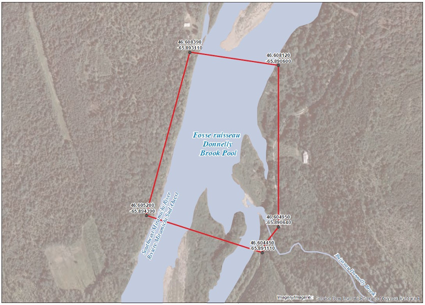
The waters of the Southwest Miramichi River area located at the mouth of Donnelly Brook and including a portion of the said brook. This specific area consist of a portion of the Southwest Miramichi River inside a line drawn from (1) 46.608390, -65.893110 to (2) 46.608120, -65.890600; then to (3) 46.604950, -65.890640 to (4) 46.604450, -65.891110; and then to (5) 46.605200, -65.894390;
The waters of the Southwest Miramichi River, area located at the mouth of Betts Mill Brook and including a portion of the said brook. This specific area consist of a portion of the Southwest Miramichi River inside a line drawn from (1) 46.541760, -66.186060 to (2) 46.538810, -66.183290; then to (3) 46.538530, -66.183760 to (4) 46.538160, -66.188590; and then to (5) 45.540100, -66.190240;
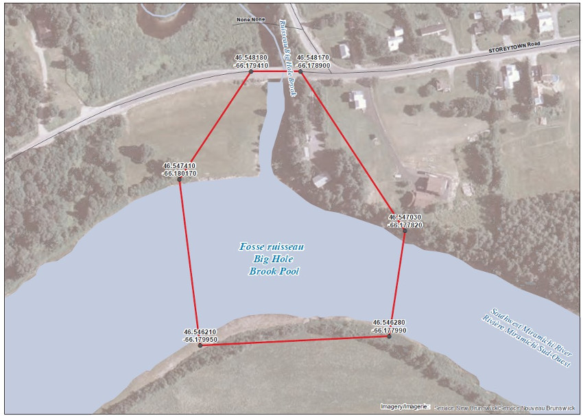
The waters of the Southwest Miramichi River, area located at the mouth of Big Hole Brook and including a portion of the said brook. This specific area consist of a portion of the Southwest Miramichi River inside a line drawn from (1) 46.548180, -66.179410 to (2) 46.548170, -66.178900; then to (3) 46.547030, -66.177820 to (4) 46.54280, -66-179950; then to (5) 46.546210, -66.179950 and to (6) 46.547410, -66.180170;
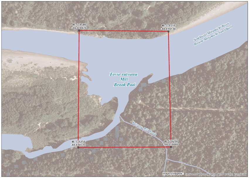
The waters of the Southwest Miramichi River, area located at the mouth of Mill Brook and including a portion of the said brook. This specific area consist of a portion of the Southwest Miramichi River inside a line drawn from (1) 46.578510, -66.016130 to (2) 46.576250, -66.016080; then to (3) 46.576250, -66.018710 and to (4) 46.578540, -66.018670;
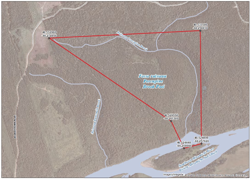
The waters of the Southwest Miramichi River, located at the mouth of Porcupine Brook and including a portion of the said brook. This specific area consist of a portion of the Southwest Miramichi River inside a line drawn from (1) 46.533500, -66.258030 to (2) 46.524800, -66.257920; then to (3) 46.524440, -66.259860 to (4) 46.526550, -66.261300; and then to (5) 46.532960, -66.274850;
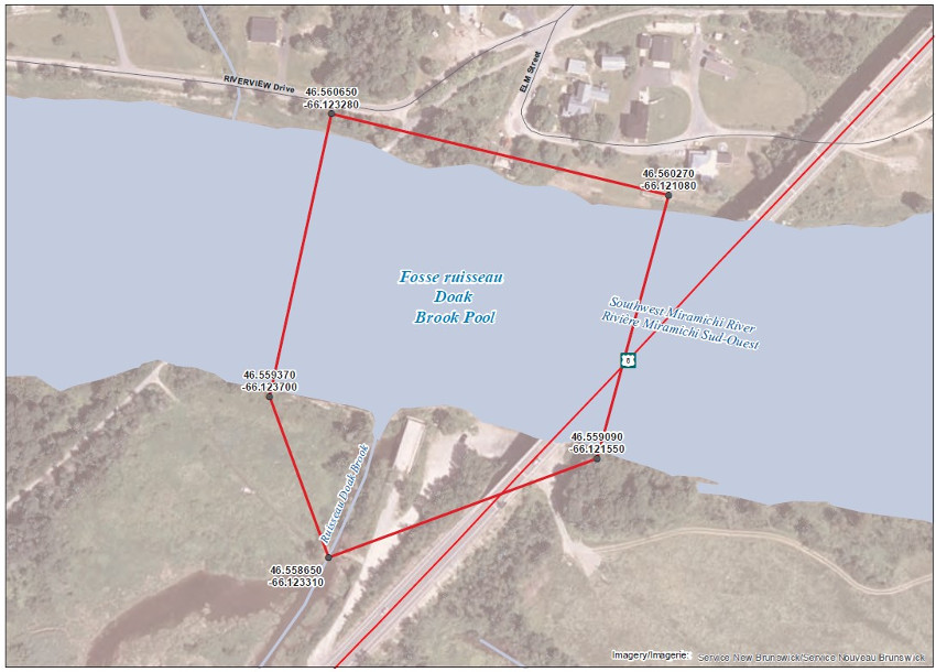
The waters of the Southwest Miramichi River in Doaktown, area located at the mouth of Doak Brook and including a portion of the said brook. This specific area consist of a portion of the Southwest Miramichi River inside a line drawn from (1) 46.560270, -66.121080 to (2) 46.559090, -66.121550; then to (3) 46.558650, -66.123310 to (4) 46.559370, -66.123700; and then to (5) 46.560650, -66.123280;
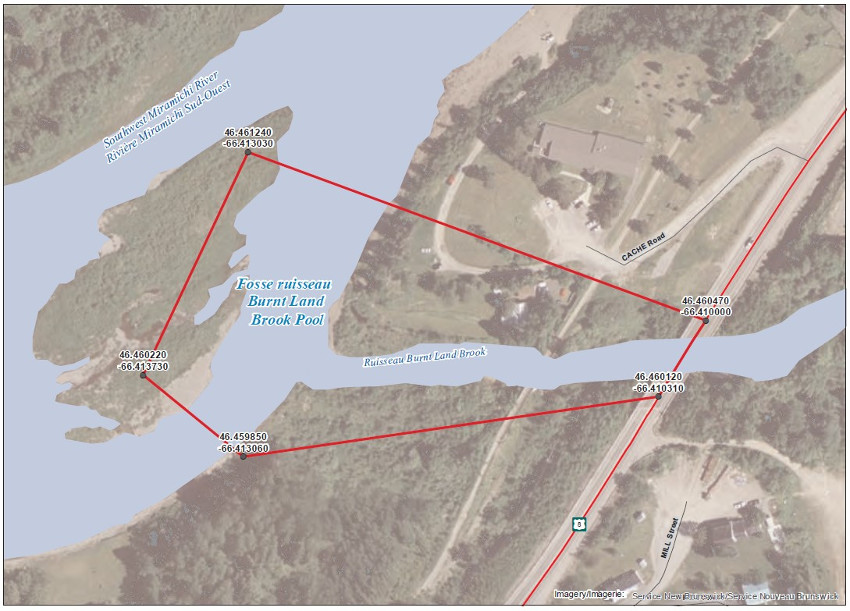
The waters of the Southwest Miramichi River, area located at the mouth of Burnt Land Brook and including a portion of the said brook. This specific area consists of a portion of the Southwest Miramichi River inside a line drawn from (1) 46.461240, -66.413030 to (2) 46.460470, -66.410000; then to (3) 46.460120, -66.410310 to (4) 46.459850, -66.413060; and then to (5) 46.460220, -66.413730;
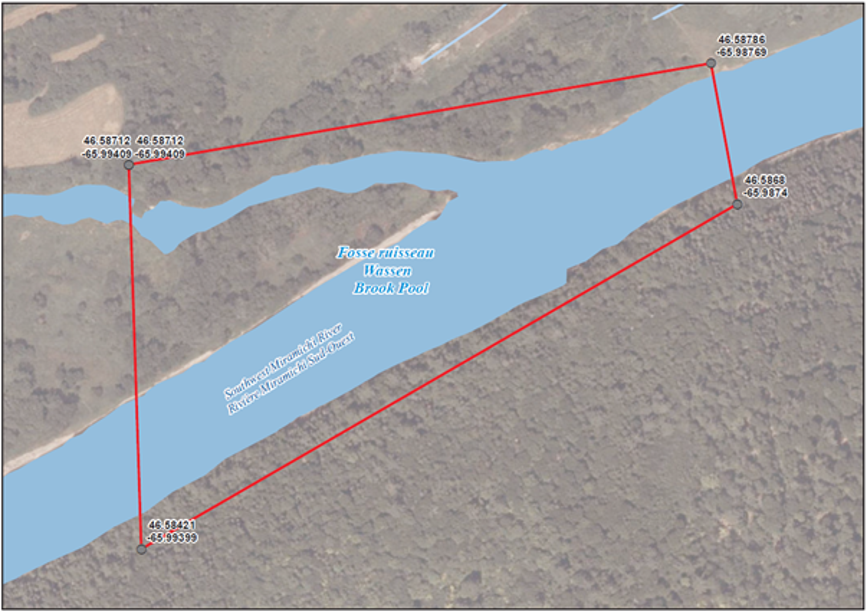
The waters of the Southwest Miramichi River, area located at the mouth of Wassen Brook and including a portion of the said brook. This specific area consists of a portion of the Southwest Miramichi River inside a line drawn from (1) 46.58786, -65.98769; to (2) 46.58680, -65.98740; then to (3) 46.58421, -65.99399 and to (4) 46.58712, -65.99409 (North American Datum 1983)
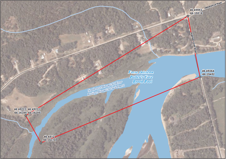
The waters of the Southwest Miramichi River, area located at the mouth of Porter’s Brook and including a portion of the said brook. This specific area consists of a portion of the Southwest Miramichi River inside a line drawn from (1) 46.49593, -66.35518; to (2) 46.49364, -66.35452; and then to (3) 46.49120, -66.36314 to (4) 46.49222, -66.36395 (North American Datum 1983)
Renous River
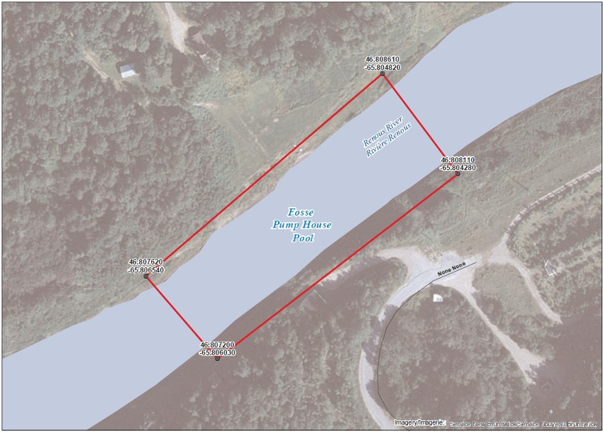
The waters of Renous River, area located at the pump house. This specific area consists of a portion of the Renous River inside a line drawn from (1) 46.808610, -65.804820 to (2) 46.808110; -65.804280 then to (3) 46.807200, -65.806030 and to (4) 46.807620, -65.806540 ;
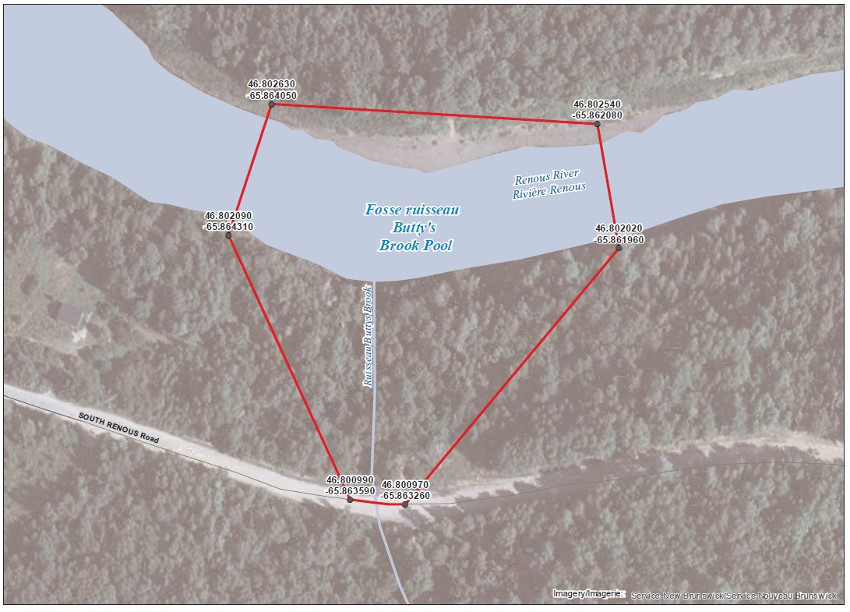
The waters of the Renous River, area located at the mouth of Butty’s Brook and including a portion of the said brook, area locally known as Duffy’s Brook. This specific area consist of a portion of the Renous River inside a line drawn from (1) 46.802540, -65.862080 to (2) 46.802020, -65.861960; then to (3) 46.800970, -65.863260; to (4) 46.800990, -65.863590; then to (5) 46.802090, -65.864310; and to (6) 46.802630, -65.864050;
Cains River
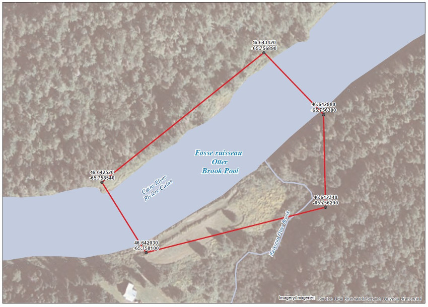
The waters of Cains River, area located at the mouth of Otter Brook and including of the said brook, this is also locally known as Brophy’s Place. This specific area consist of a portion of the Cains River inside a line drawn from (1) 46.643420, -65.756890 to (2) 46.642980, -65.756300; then to (3) 46.642640, -65.756230 to (4) 46.642030, -65.758100; and then to (5) 46.642520 to -65.758540;
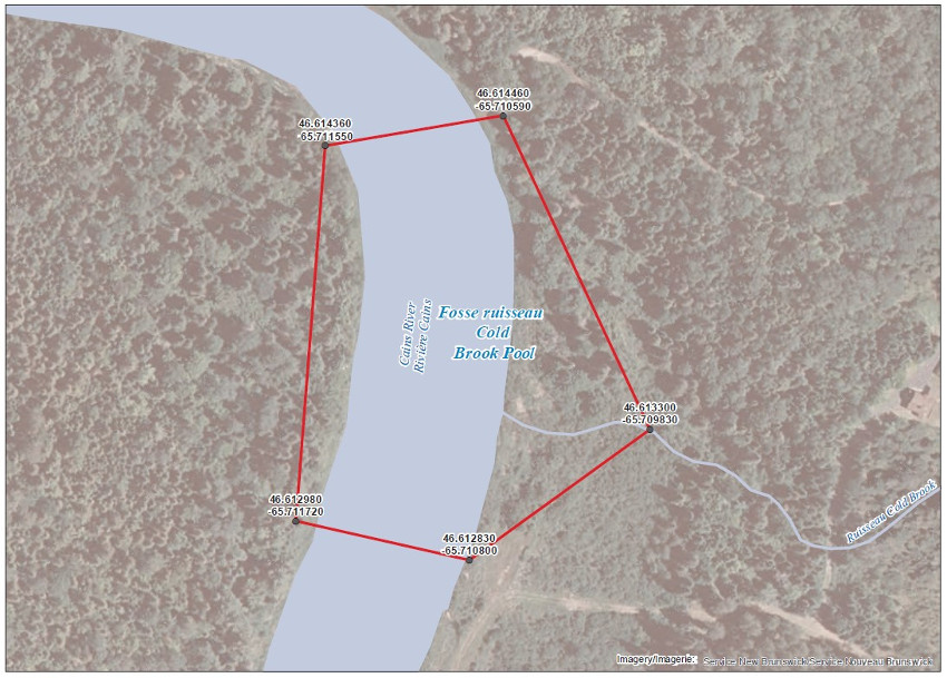
The waters of the Cains River, area located at the mouth of Cold Brook and including a portion of the said brook. This specific area consist of a portion of the Cains River inside a line drawn from (1) 46.614460, -65.710590 to (2) 46.613300, -65.709830; then to (3) 46.612830, -65.710800 to (4) 46.612980, -65.711720; and then to (5) 46.614360, -65.711550;
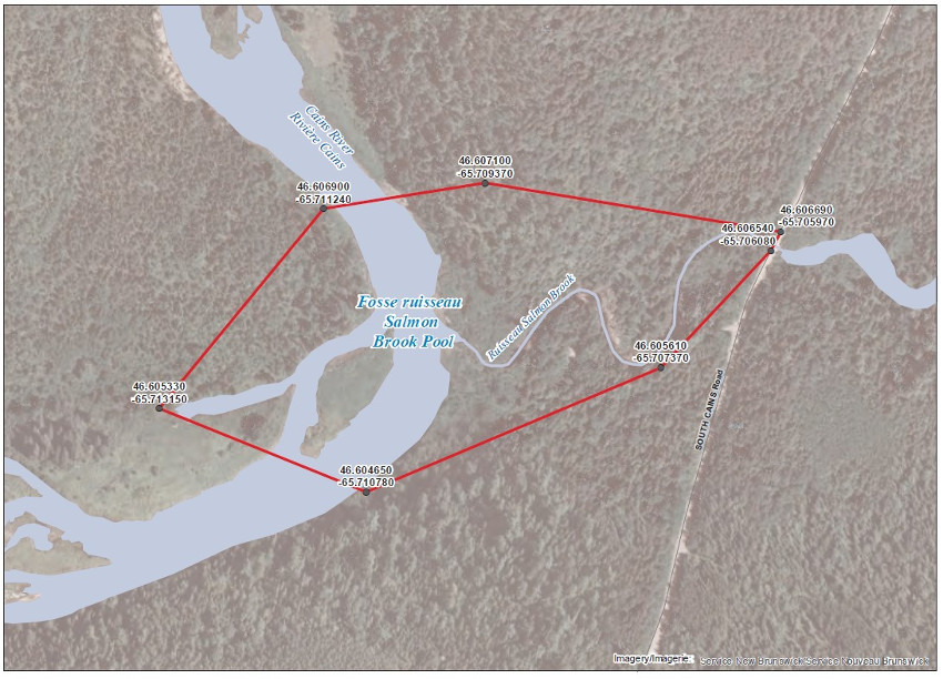
The waters of Cains River, area located at the mouth of Salmon Brook and including a portion of the said brook. This specific area consists of a portion of the Cains River inside a line drawn from (1) 46.607100, -65.709370 to (2) 46.606690, -65.705970; then to (3) 46.606540, -65.706080 to (4) 46.605610, -65707370; to (5) 46.604650, -65.710780 to (6) 46.605330, -65.713150 and then to (7) 46.606900, -65.711240;
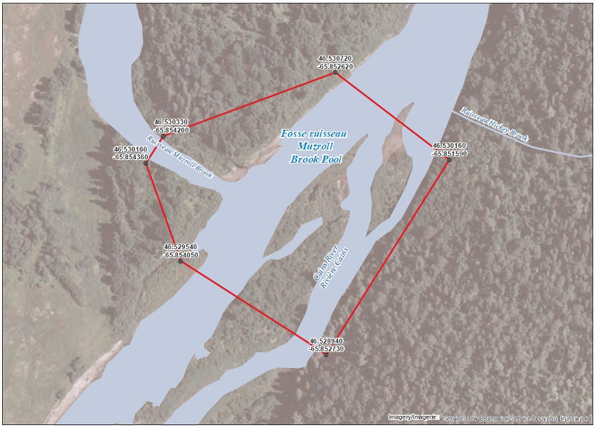
The waters of the Cains River, area located at the mouth of Muzroll Brook and including a portion of the said brook. This specific area consist of a portion of the Cains River inside a line drawn from (1) 46.530720, -65.852620 to (2) 46.530160, -65.851590; then to (3) 46.528940, -65.852730 to (4) 46.529540, -65.854050; to (5) 46.530160, -65.854360 to and then to(6) 46.530330, -65.854200;
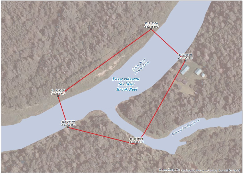
The waters of the Cains River, area located at the mouth of Six Mile Brook and including a portion of the said brook. This specific area consist of a portion of the Cains River inside a line drawn from (1) 46.510360, -65.855590 to (2) 46.509970, -65.855000; then to (3) 46.508960, -65.855870 to (4) 46.509170, -65.857060; and then to (5) 46.509560, -65.857240;
Please also note that the following salmon holding pools are closed to all angling methods from July 1st to December 31st, 2022:
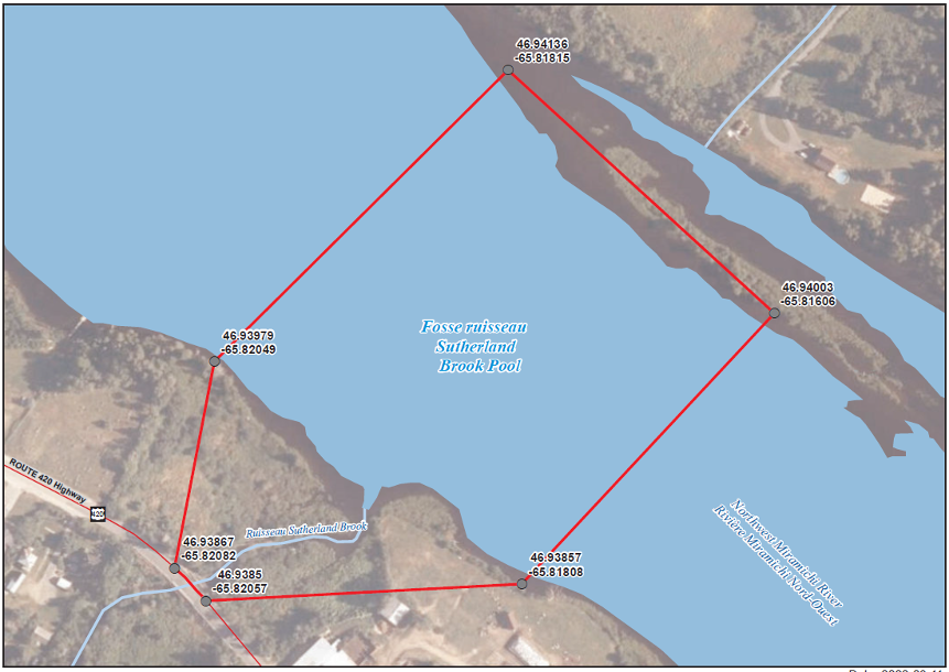
The waters of Northwest Miramichi River, area located at the mouth of Sutherland Brook and including a portion of the said brook. This specific area consists of a portion of the Northwest Miramichi River inside a line drawn from (1) 46.94136, -65.81815 to (2) 46.94003, -65.81606; then to (3) 46.93857, -65.81808 to (4) 46.93850, -65.82057; to (5) 46.93867, -65.82082; and then to (6) 46.93979, -65.82049.
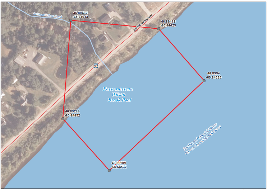
The waters of the Southwest Miramichi River located at the mouth of Wilson Brook and including a portion of the said brook. This specific area consists of a portion of the Southwest Miramichi River inside a line drawn from (1) 46.89432, -65.64613; to (2) 46.89418, -65.64423; then to (3) 46.89340, -65.64325 to (4) 46.89209, -65.64532; and then to (5) 46.89286, -65.64632.
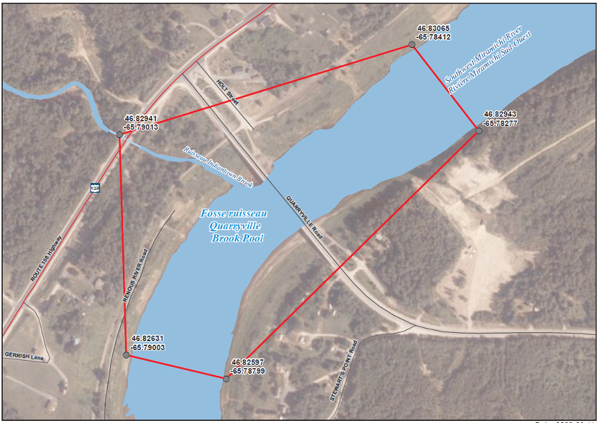
The waters of the Southwest Miramichi River area located at the mouth of Indiantown Brook and including a portion of the said brook next to Quarryville Bridge. This specific area consists of a portion of the Southwest Miramichi River inside a line drawn from (1) 46.82941, -65.79013; to (2) 46.83065, -65.78412; then to (3) 46.82943, -65.78277 to (4) 46.82597, -65.78799; and then to (5) 46.82631, -65.79003.
Note: All the coordinates mentioned until this point are in latitude and longitude in Decimal Degrees (DD) and are all referenced with the North American Datum 1983.